Routes
QUÉBEC BIKEPACKING TRAVERSE – SEGMENTS
The route
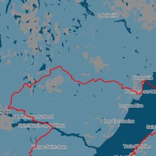
Il s’agit d’un projet en constante évolution et l’état et l’accès à ces chemins peuvent changer en tout temps. Cliquez sur les segments de la carte pour rejoindre les pages descriptives détaillées ou naviguez plus bas.
Québec Bikepacking Traverse
kilometers
elevation gain
m / km
touristic regions
national parks
wildlife reserves and zecs
quÉbec bikepacking traverse – segments
Parce qu’on ne peut pas tous faire 3 000 km dans un été, le Québec Bikepacking Traverse est divisé en 8 segments pratiques.
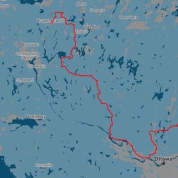
Segment I
Rouyn-Noranda – Gatineau Park
Abitibi-Témiscamingue & Outaouais
685 kilometers
5 760 m de dénivelé positif
1 national park, 1 wildlife reserve, 2 zecs
28% vérifié
Segment II
Gatineau Park – Mont-Tremblant
Outaouais & Laurentides
259 kilomètres
2 673 m de dénivelé positif
1 wildlife reserve
100% verified
Segment III
Mont-Tremblant – Rivière-à-Pierre
Laurentides, Lanaudière, Mauricie & Québec
459 kilomètres
4 960 m de dénivelé positif
1 national park, 2 wildlife reserves, 3 zecs
100% verified
Segment IV
Rivière-à-Pierre – parc du Fjord-du-Saguenay
Québec, Charlevoix & Saguenay-Lac-St-Jean
345 kilometers
4,455 m elevation gain
2 parcs nationaux, 2 réserves faunique, 3 zecs
68% vérifié
Segment V
Sainte-Rose-du-Nord – Forestville
Saguenay-Lac-St-Jean & Manicouagan
258 kilometers
3,100 m elevation gain
1 national park, 2 zecs
30% vérifié
Segment VI
Rimouski – Lac-Témiscouata Park
Bas-Saint-Laurent
215 kilometers
2 002 m de dénivelé positif
2 national parks
100% verified
Segment VII
Lac-Témiscouata Park – Gaspésie Park
Bas-Saint-Laurent & Gaspésie
391 kilometers
5,584 m elevation gain
2 national parks, 2 wildlife reserves, 2 zecs
95% vérifié
Segment VIII
Gaspésie Park – Gaspé
Gaspésie
432 kilometers
7,300 m elevation gain
3 national parks, 1 wildlife reserves, 2 zecss
75% vérifié
Le QcBT est la colonne vertébrale d’un réseau d’itinéraires de bikepacking au Québec. Découvrez-en plus.
Say what you think
Terms of use : As with each route published on bikepacking.quebec, should you choose to cycle this route, or use any other means of transportation, do so at your own risk. The creators of bikepacking.quebec, its partners, associates, and contributors are in no way liable for personal injury, damage to personal property, or any other such situation that might happen to individuals following this route. The information found herein is a planning and inspiration resource. Despite the fact that the information on this page, as well as the associated map and GPS track (GPX and maps), were researched, prepared and published diligently, the accuracy of those informations is not guaranteed. Before leaving, check current local weather as well as roads and paths conditions and potential closures. While riding, obey all public authorities instructions and restrictions, respect private land, carry first aid, repairs and navigational equipment, respect the environment, and of course, use common sense.
